Welcome to The Three Rivers!

After floating through the hilly Piedmont, you arrive at the Sandhills of South Carolina. Between 55 and 100 million years ago, sea level was higher, and the coast was farther inland. Marine fossils and beach sand remain as evidence of the ancient beachfront in the Sandhills. Over millions of years, sea level dropped, and by 10,000 BCE, humans occupied the central area of the state.

Begin

Congaree Town

Saluda, Congaree, Wateree, and Santee…names that remind us of the people who first lived near the Three Rivers area. Native Americans inhabited the backcountry of South Carolina over 10,000 years before the arrival of Europeans. Like cities of today, early villages used waterways for irrigation, drinking water, hunting, fishing and transportation.

In the 1690s, English trader John Lawson explored the interior of South Carolina. His journal shows that the native Congaree people suffered from smallpox, a deadly disease introduced by the European colonists. Lawson mentions a village known as "Congaree Town" that some believe was located on the west bank of the Congaree, across the river from present day Columbia. Others believe Lawson was disoriented, and the town was closer to the Santee River.

Close

THEODORE DE BRY, 1590

Burning and scraping a dugout canoe

SCETV

Precolonial village in southeastern U.S.

SCETV

Corn was introduced to Europeans by the Native American

Clue:

The Columbia area has been occupied for over 10,000 years. Europeans introduced diseases that took a heavy toll on Native American populations.

Add clue to notebook

SCETV

Route of explorer John Lawson, 1700

Next
Prev

Cayce House

A prisoner of the British troops at Fort Granby, eighteen-year-old Emily Geiger memorized the secret note she carried from American General Nathaniel Greene. Before her captors could search her, Emily swallowed the note, and, with no evidence of disloyalty, she was released. Emily continued on horseback over a hundred miles toward the camp of General Thomas Sumter. With the message delivered, the American generals rallied their forces to overtake the prized fort on the Congaree River.

Fort Granby, known as the "Cayce House," had many lives – as a trading post, a British stronghold, and family home. Today, a near replica of the building serves as the Cayce Historical Museum and a reminder of Columbia’s forbears.

The original trading post (1765), or Granby Store, served travelers moving through the backcountry along the Old State Road. At the post, Native Americans traded deer hides for metal axes and settlers stocked supplies for a long trip to the coast or mountains.

During the Revolutionary War, the trading post served as a recruiting station, paymaster, and supply hub for American armies. British troops seized the structure in 1781, and fortified it with trenches and earthworks. Colonial troops repeatedly laid siege to Fort Granby, recapturing it on July 4, 1781.

Wade Hampton (1754-1835), the original owner of the Granby Store, became a state legislator (1779-1786), and U.S. congressman (1803-1805) after the war. Hampton owned large tracts of farmland on the Congaree, part of which he sold to the emerging capital city.

After the Cayce family bought the house in 1817, it served as a private residence for the next 100 years. As the surrounding town of Granby declined, a new city named after the Cayce family took root. Bearing the scars of a cannonball from the Revolutionary War, and nearly 200 years of history, the “Cayce House” was demolished in 1952. Today, people can see a recreation of the house at the Cayce Historical Museum.
Close

SCETV

Cayce House, 1765-1952

SCETV

Emily Geiger’s ride, 1781

River Alliance

Cayce House as Fort Granby, 1781

River Alliance

Bird’s eye view of Fort Granby, 1781

Clue:

As an early trading post (1765), British fort (1780), and family home (1817), the Cayce House led to future settlement in central South Carolina.

Add clue to notebook

SCETV

Cayce House as family home

Cayce Historical Museum

Cayce Historical Museum

Next
Prev

Friday's Ferry (1754)

“All could not cross until the next day… and not without cost and loss of seven horses which drowned,” reported Spanish explorer Hernando DeSoto after he arrived at the Saluda River in 1540. Over two hundred years later, Martin Fridig, a German settler, decided the area needed a reliable river crossing. Without means to build a bridge, Fridig (Friday) established ferryboat service over the Congaree River in 1754.

Fridig’s wide, flat boat ferried people, horses, and wagons across the river to landings on the riverbanks. With an established river crossing, travelers were drawn to the area as they moved between upcountry and lowcountry routes on either side of the river. Ministers, Native Americans, and public servants crossed for free, while others paid a shilling, three pence, or about 75¢ in today’s U.S. currency.

Close

ETV

Ferry boat, 19th century

National Park Service

Hernando De Soto route, 1540

Clue:

Activity around Friday’s Ferry stimulated growth in the Congaree River area. The boat connected major land routes between upcountry and lowcountry South Carolina.

Add clue to notebook

SCDPT

Ashe’s Ferry, Van Wyck, South Carolina, c. 1952

Next
Prev

Old Fort Congaree (1718)

What Native Americans called home, the colonists called the frontier. Hostilities between settlers and native people threw South Carolina’s backcountry into war in 1715. The Cherokee, a tribe with great influence over the frontier but a base in the upcountry, sided with the English to push the Yemassee, Congaree and Wateree tribes out of central South Carolina. The Yemassee War (1715-1716) forever changed the cultural landscape of the area.

The Yemassee War led to trade agreements between the English colony and the Cherokee. Using Cherokee labor, the English built OId Fort Congaree as a backcountry outpost and trade center, outfitting it with up to 20 troops. After the post was abandoned in 1722, Thomas Brown, an Irish settler, restored trade in the area by building a new post in 1733. Brown’s post thrived as native and European traders exchanged goods from as far west as the Mississippi and as far north as New York state.

Close

ETV

Old Fort Congaree served as a backcountry trading post

Clue:

Trading posts like Old Fort Congaree (1718) expanded European settlement into the backcountry of South Carolina.

Add clue to notebook

Town of Granby (1735)

The busy streets and fine homes of Granby once rivaled those of the emerging capital city across the river. Merchants bought and sold tobacco in the city’s market, while hotels accommodated traders and curious travelers passing through the backcountry. Mills ground corn into flour and sawed logs into boards, and a blacksmith kept wagons rolling with raw goods. The area’s first courthouse, jail, and post office were erected to serve the growing community.

Once known as “the Congarees,” Granby was at its peak in the 1780s with a population of 800 residents and a reputation of being the most important trade town east of the Mississippi. But the town of Granby was short-lived as Columbia took the spotlight as the financial center of the state. Some families left Granby to live in Columbia, while others established the town of Cayce. Though Granby was nearly deserted by 1840, its brief success helped establish the new state capital.

Close

ETV

Recreation of the Town of Granby, mid 1700s

ETV

Local mills provided flour, lumber, and fabric

ETV

Cotton and tobacco were traded in Granby markets

Clue:

In the 1780s, Granby was a center of political and economic activity in central South Carolina. Rivers connected it to important trade centers downstream.

Add clue to notebook

ETV

The historic “Cayce House” was nearby

ETV

Map of Granby

ETV

Headstone from Granby graveyard

Next
Prev

Saxe Gotha Township

Saxe Gotha, an area east of the Congaree River, was originally part of the colonial Township system. In the early 1700s, the capital of Charles Towne (renamed Charleston) felt threatened by slave revolts, foreign invaders, and attacks by Native Americans. To protect Charles Towne, backcountry settlements, called Townships, were created in the interior of South Carolina. Townships were large districts with a town that served as the financial and political seat of the area. Colonial settlers who moved to backcountry Townships received free land and provisions.

Saxe Gotha Township was laid out in 1730, covering about seven square miles of land. To attract increasing numbers of German immigrants, Saxe Gotha took its name from a German town. Settlers were granted half acre lots in Saxe Gotha Town, and farmland in the surrounding district. The town’s location on the Cherokee Path (Old State Road) prevented hostile invaders from using the route to enter Charleston.

By 1759, the population of Saxe Gotha exceeded 800 people, mostly German and Irish. English settlers, African slaves and settlers from other colonies also lived in the area. As a whole, the town’s economy prospered. Cotton was the new cash crop of the backcountry, and the settlers’ bountiful crops were traded in local and international markets.

Townships laid the foundation for many emerging districts and counties. Lexington County, founded in 1785, absorbed the Saxe Gotha population. The counties of Orangeburg, Williamsburg, and Florence grew out of townships as well.

Close

ETV

Free farmland was given to settlers in townships

ETV

Settlers looked to the backcountry for religious freedom

ETV

House from era of Saxe Gotha Township

Saxegotha

Townships, 1731 – 1765

ETV

Map from mid 1700s showing Saxe Gotha Township

Clue:

Saxe Gotha was one of many Townships that were developed to protect the Charles Towne from invaders. Townships laid the foundation for many of South Carolina’s emerging districts and counties.

Add clue to notebook

ETV

Home from Saxe Gotha area, mid 1700s

Next
Prev

Washington's Visit

In 1791, President George Washington traveled to Columbia over the bumpy Old State Road, through the polished city of Granby, and across the Congaree River by ferryboat. His diary reveals the challenges Columbia faced as it tried to establish itself as the political and social center of the state. It was a city in the awkward throes of youth.

“Columbia is laid out upon a large scale; but, in my opinion had better been placed on the River below the falls - It is now an uncleared wood, with very few houses in it, and those all wooden ones… The Town is on dry, but cannot be called high ground, and though surrounded by Piney & Sandy land is, itself good...From Granby the River is navigable for Craft which will, when the River is a little swelled, carry 3000 bushels of Grain.”

Close

Cayce Historical Museum

Washington views Columbia from the Old State Road

Timeline - Columbia

Growth was certain for a city that was home to state government, a major university, a wealth of natural resources, and a growing industrial base. How did the modern city of Columbia develop economically? Here are a few highlights:

In 1754, ferry service on the river connected settlers to the Old State Road, the earliest major land route through the state. Trading posts grew up around the ferry service as merchants moved between the upcountry and the lowcountry.

In 1786, state government began planning a capital city of 400 blocks on two square miles of land along the Congaree River. “Columbia” was near the geographic center of the state, a location that lent itself to being a center of trade and state government. The abundance of area rivers served growing needs for drinking water and transportation. Plentiful granite, alluvial clay, and lumber provided building materials and trade goods.

By the early 1800s, canals and locks provided safe passage for riverboats traveling across the state. Restaurants, hotels and other services accommodated traders who stopped to buy, sell, and rest. Railroads replaced canals in the 1840s, and soon Columbia became a major railroad hub.

The early 1900’s saw a boom in textile mills powered by hydroelectricity. Columbia competed with nearby cities of Greenville and Augusta to become the center of southeastern textile production.

By the 1960s, the textile industry had slowed down, and by the 1980s, it had virtually disappeared. But Columbia’s population of state and federal employees grew dramatically from the 1950s to the 1980s. The business of government became Columbia’s economic backbone.

During the latter part of the 20th century, the University of South Carolina and Fort Jackson grew rapidly. Industries such as technology, telecommunications, and electricity eventually replaced textiles. Today, Columbia, with over 100,000 people, is South Carolina’s most populated city.

Close

SC Dept of Archives

Thomas Taylor’s plantation on the Congaree, late 1700s

ETV

Columbia, 1825

ETV

Columbia, 1920

ETV

Columbia, aerial photograph taken in 1994

Clue:

Columbia was designated the capital of South Carolina in 1786. Bridges, canals and locks connected the city to major trade routes. In the early 1900s, textile mills provided an economic boon to the city. Today, state government and industries such as technology, telecommunications, and electricity are Columbia’s economic backbone.

Add clue to notebook

ETV

Columbia, 2004

Next
Prev

Cherokee Path, State Road

Cars on Interstate 26 follow a trail that existed hundreds of years prior to European contact. Native American paths awaited colonial settlers when they pushed into the interior of South Carolina. One early land route, the Cherokee Path, connected the Cherokee nation of the Blue Ridge to the coast of South Carolina. The path cut through high ground along the Santee, Congaree, and Saluda Rivers.

The Cherokee Path led to trade, communication, and sometimes war between the Cherokee and other tribes including the Catawba, Wateree and Congaree. Colonists used the route to establish inland trading posts, and the size of the path grew to accommodate their horses and wagons.

In 1734, the colonial Town of Saxe Gotha, located on the Congaree, asked government for bridges and better roads for its growing population. By 1820, the road was widened to 30 feet, and was known as the “State Road.”

The Cherokee Path and Old State Road are perhaps the oldest and most traveled routes in South Carolina, with a few stretches of the original road still fit for foot or car travel. Interstate 26, a modern freeway, uses a similar route to connect the upstate to the coast.

Close

ETV

Cherokee village of the upstate

CAYCE HISTORICAL MUSEUM

Mile marker from Old State Road

ETV

Old State Road, today

ETV

I-26 follows the approximate route of the Cherokee Path

Clue:

The Cherokee Path led to trade, communication, and sometimes war between the Cherokee and other tribes. Colonial settlement followed in the footsteps of the Native Americans.

Add clue to notebook
Next
Prev

Columbia Becomes Capital

“Our amusement is Business of State,
Centrically placed for our ease:
Without shrimps, or oysters in pies,
So delegates fare as you please.”

-Excerpt from A Trip to Columbia
State Gazette of South-Carolina, 1789

So the business of moving the state capital from Charleston to Columbia began, but not without fierce debate. One lawmaker said a capital in the backcountry would become a “town of refuge,” inviting only to thieves and roughnecks. During the colonial era, Charleston was the center of politics, the economy, and society. Some lawmakers considered the “backcountry” lawless and unrefined, a place where they would long for entertainment and comfort.

After the Revolutionary War, state government took a fresh look at its people and resources. Blue Ridge and Piedmont populations had grown considerably, but lacked a voice in state government. In 1786, a centrally located capital city was proposed near Friday’s Ferry, a trade hub on the Congaree. Columbia, named for Christopher Columbus, was a planned city of 400 blocks, with land assigned to residential, business and government needs. Access to three rivers promised to network communication, trade, and transportation in the state. The first statehouse was erected in 1788, and slowly Columbia grew into its role as political hub of the state.

Close

South Caroliniana Library

South Carolina’s first statehouse, 1790s

SCDAH

South Carolina Statehouse, 1855

Clue:

Columbia, a planned city located in the center of the state, became the new capital in 1786. Access to rivers promised to network the state’s communication, trade, and transportation routes.

Add clue to notebook

SCETV

South Carolina Statehouse

Next
Prev

Mosquito

What does the lowly mosquito have to do with the growth of Columbia? Mosquitoes spread diseases such as malaria and yellow fever, both of which took a heavy toll on colonial settlements. Standing water found near rivers, swamps, rice fields and other wetlands are breeding grounds for mosquitos.

The scourge of mosquitoes and disease eventually outweighed the advantages of living in villages near area rivers. Columbia was inland from the river and situated on a hill, and many people left Granby for the less disease-prone capital. Mosquitoes even played a part in the city plan of Columbia. The city’s wide streets were designed to allow breezes to blow through town and, in theory, keep mosquitoes at bay.

Close

NOAA

Mosquitos thrive in wetlands

SCETV

Granby was located on bottomland along the Congaree River

State Museum Collection

View of Columbia from Granby area, 1845

Clue:

Mosquitoes spread diseases such as malaria and yellow fever, both of which took a heavy toll on colonial settlements. Standing water found near rivers, swamps, rice fields and other wetlands are breeding grounds for mosquitos.

Add clue to notebook
Next
Prev

Ruins of the Old Mill

Hidden among the rocks and dense flora of the Saluda Rapids are granite walls that were part of the Saluda Factory, the first major textile mill in Columbia. The Saluda Factory was built between 1828 and the mid-1830s. A dam diverted river water through two 18-foot undershot water wheels. The undershot wheels powered looms, spindles, and other machinery that produced “Southern Stripe,” a heavy brown cloth used in durable clothing. Eventually a wool weaving mill was added, and the factory increased production of cloth goods.

The Saluda Factory produced around 50,000 wool uniforms for soldiers in the Confederate Army. The factory itself was the stage for a major event of the Civil War. On February 17, 1865, General Sherman and his Union troops plotted their assault on Columbia from the banks of the Saluda River. Troops seized the Saluda Factory and used its upper levels to get a vantage point on the city. Through the factory’s windows, sharp shooters protected Sherman and his soldiers as they crossed the Saluda River on a pontoon bridge. Sherman’s troops set fire to the Saluda Factory as Columbia fell to Union forces.

Close

ETV

The Saluda Factory produced textiles during the 1800s

Riverbanks Zoo

Footprint of the Saluda Factory

ETV

A dam diverted water through a raceway toward the waterwheel

ETV

An undershot waterwheel

PRATT MEMORIAL LIBRARY

The Saluda Factory burns as Sherman marches on Columbia, 1765

Clue:

The Saluda Factory was a step toward developing Columbia’s textile industry. Its waterwheels were powered by the Saluda River.

Add clue to notebook

ETV

Arch from Saluda Factory

Next
Prev

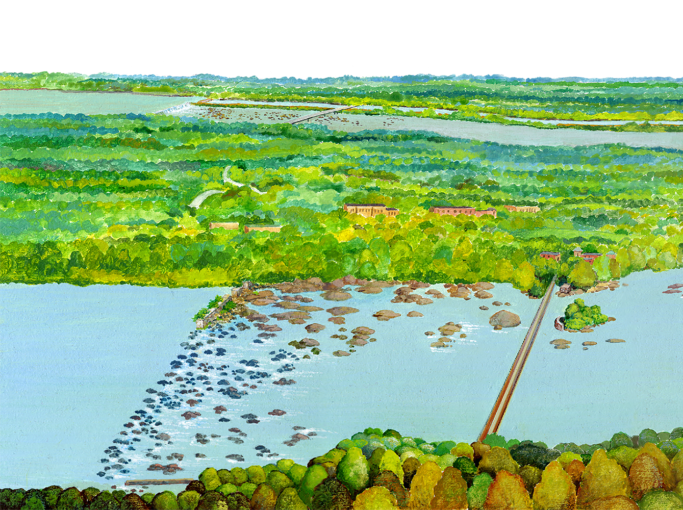
Ruins of Saluda Bridge and Canal

Along the river, trees and vines hide artifacts of Columbia’s past. An island of granite blocks is all that remains of the Saluda Bridge. By linking Columbia to the Old State Road, a major land route, the Saluda Bridge networked the city to other parts of the state. The advantage became dangerous during the Civil War, and the bridge was one of several burned to prevent Union Soldiers from entering Columbia.

Near the bridge, a few block walls, a dip in the earth, and remnants of a lock reveal the location of the Saluda Canal. Built between 1818 and 1823, the canal helped riverboats get around shallow water and rocky rapids on the Saluda River. Flooding, drought, floating debris, and labor costs took a heavy toll on the canal, and the service was forced to shut down in 1837.

Close

ETV

Footing of the Saluda Bridge

ETV

Remains of a lock on the Saluda Canal

ETV

Canals helped boats evade river rapids and shallow water.

Clue:

The Saluda Bridge and Canal are historic sites that reveal Columbia’s growing transportation needs in the early 1800s.

Add clue to notebook

ETV

Rapids on the Saluda River

Next
Prev

1845 View of Columbia

Columbia barely had a skyline when this image was painted in 1845, but signs of construction can be seen in the distance. The covered Congaree Bridge was located in the area of the current Gervais Street bridge.

Close

South Carolina State Museum

1845 View of Columbia by Dovilliers

1872 Bird's Eye View of Columbia

“Birds eye” views of the 19th century promoted the idea of prosperity and growth in cities of the United States. To compose this image, the artist Camille Drie used maps and walked the streets of Columbia making sketches of vegetation, landmarks, businesses, and homes. The artist then interpreted what these features looked like from an elevation of 3,000 feet or higher. The founders of Columbia used the vibrant image to advertise Columbia’s commercial and residential potential.

Click here for a full-size version of the map.

Close

Library of Congress

Congaree River and Columbia Canal, 1872

Library of Congress

South Carolina StateHouse, 1872

Library of Congress

Columbia train depot, 1872

Library of Congress

University of South Carolina, 1872

Next
Prev

Carolinas Campaign

Looking toward Columbia from the west bank of the Saluda River, General Sherman and his Union troops had a dilemma. Confederate Troops burned all major bridges leading toward Columbia, the next step of Sherman’s “March to the Sea.” The downfall of South Carolina’s state capital was significant, as Union forces perceived the city as the instigator of the Civil War. With key southern cities of Atlanta, Augusta and Savannah captured, Columbia’s capture would help secure Union victory. On the morning of February 17, 1865, soldiers built a pontoon bridge over the river with wood stripped from the Saluda Factory, a large textile mill. Snipers in the windows of the factory protected Union troops as they successfully crossed the river to enter Columbia.

Union troops seized Columbia on a clear and windy day. Prior to the city’s capture, Confederate General Wade Hampton ordered all cotton bales to be taken to the street and burned. The city’s valuable cotton stores blew through the air and lodged in trees. Though still a topic of debate, it is believed fires set by Confederate and Union soldiers burned nearly two-thirds of Columbia’s historic structures. When Sherman was asked whether he gave the order to burn Columbia, he replied, “if I had made up my mind to burn Columbia I would have burnt it with no more feeling than I would a common prairie dog village; but I did not do it..."

Close

Library of Congress

General William Tecumseh Sherman, 1864

Pratt

Sherman’s troops cross a pontoon bridge over the Saluda River

ETV

Civil War era Pontoon Bridge

Clue:

During the Civil War, bridges to Columbia were burned to prevent Union troops from entering the city.

Add clue to notebook

National Archives

Cotton bales and burned city; looking north from State House

Next
Prev

Carolinas Campaign

George Washington led the nation into the Canal Era (1790-1860) with a vision of canals and rivers connecting inland cities to international seaports. Before automobiles, railroads, and airplanes, rivers were the most efficient way to transport goods. Over land, merchants could expect to pay ten times what they paid to ship goods by water.

People have built canals for over 6,000 years. Canals are manmade waterways that allow boats to travel safely around river rapids and other obstacles. Canals also connect distant rivers, creating a network of waterways similar to a network of roads and freeways.

The Columbia Canal was completed in 1824. The waterway ran parallel to the rapids of the Broad and Congaree Rivers, and its locks lowered boats 34 feet in elevation. By evading obstacles on two major rivers, the canal connected upcountry and lowcountry trade centers. River barges transported over 30,000 bails of cotton a year down the 3 1/8 mile waterway. A canal built around the rapids of the Saluda River further extended Columbia’s reach into the upcountry. Downriver, the Santee Canal (1800) linked boats to the Cooper River, completing the route from the upstate to the Charleston seaport.

Canals had their share of problems. Floods and droughts affected the flow of water through the canal, and maintenance of the waterway required many laborers. Eventually, the same technology that made steamships possible led to the demise of canals. In the 1840s, much of the canal system was replaced by an efficient and easier to maintain system of railroads.

Close

GIBBES MUSEUM OF ART

View of Columbia Canal, 1859

South Carolina State Museum

In the early 1800s, poleboats traveled up to 50 miles a day

Clue:

In the early 1800s, the Columbia Canal was part of a network of canals that allowed riverboat travel between the upcountry and the lowcountry. Trade activity in the area supported a growing number of merchants, warehouses, hotels, and full-time residents.

Add clue to notebook

South Carolina Wildlife

The Columbia Canal runs parallel to the Broad River

Next
Prev

Rebirth of the Canal

In November of 1891, people crowded the banks of the old Columbia Canal as mayor F.W. McMaster gave a speech, bells and whistles screeched, and a cannon fired on Arsenal Hill. The canal’s large, new gates opened and water flowed toward the first hydroelectric plant in Columbia. Electric powered lights, street cars, and most importantly, textile mills soon followed.

The Columbia Canal had fallen into disrepair in the 1840s. Traders chose the speed and ease of railroads over the slow, unreliable pace of river transport. The rebirth of the waterway began when investors saw how a deeper, wider canal could fuel a new invention, the hydroelectric power plant. Convicts from the State Penitentiary enlarged the canal and built a dam to divert water from the Broad River into the waterway. The canal’s flow continues to power the Columbia Hydro Plant, located near the confluence of the Congaree River.

Close

ETV

Dam diverting water from the Broad River into the Columbia Canal

ETV

Control gates on Columbia Canal

ETV

Canal lock built near gates, 1891

ETV

Mt. Vernon Power Plant, located at the end of the canal

HOWARD G WOODY POSTCARD COLLECTION

Main Street, Columbia, 1910

Clue:

In 1891, the Columbia Canal was tapped as a source of water for Columbia’s first hydroelectric powerplant.

Add clue to notebook
Next
Prev

S.S. Columbia

When water levels are low, the muddy remains of the S.S. Columbia, a paddlewheel steamer, emerge from the Congaree River. Riverboat traffic peaked in the early 1800’s, and by 1845, railroads replaced the need for riverboat service. The Congaree River eventually clogged with trees, and riverboats were not seen for another half century.

In the early 1900s, rail service became too expensive for some traders, and riverboats returned to the Congaree. The S.S. Columbia carried passengers, cotton and lumber goods downriver to Charleston, a journey of about 22 hours. Drought and floods once again rendered the Congaree River unnavigable in 1916, and trade eventually returned to railroads. The S.S. Columbia slowly went to wrack and ruin, leaving only its decayed hull as a reminder of Columbia’s riverboat past.

Close

ETV

Remains of S.S. Columbia, west bank of Congaree River

Cheraw Visitor's Bureau

A paddle wheel steamer, 1900

South Caroliniana Library

Boats along Congaree River, 1913

Clue:

In the early 1900s, riverboat traffic returned to the Congaree as rail service became too expensive for passengers and traders. The river’s unpredictable flow rendered it unnavigable by 1916.

Add clue to notebook
Next
Prev

The Duck Mill (1894 - 1980)

Soldiers on World War II battlefields slept in tents, carried packs, and wore shoes made with cloth from the Columbia Mills Company. Locals called the textile plant the “Duck Mill” because of the millions of yards of cotton “duck” cloth produced during the war effort. Duck cloth was tough, rot-resistant, and perfect for military use.

The looms of the Columbia Mills Company, the first electric powered textile mill in the world, began spinning in 1894. Columbia Mills was, from the ground up, a product of readily available natural resources. The building was built with bricks of alluvial clay, granite blocks from local quarries, and lumber from area forests. The mill’s machines were powered by hydroelectricity generated on nearby rivers, and processed cotton from local farms.

Working conditions in southern mills of the early 20th century were often poor. In 1903, children as young as 10 years old were allowed to work in mills. Mills were noisy, and cotton dust choked the lungs of workers, sometimes causing a serious illness called “brown lung.” Shifts were twelve hours long, six days a week. The machinery was dangerous, and the summer heat was overwhelming. As the century progressed, labor laws were enacted to protect workers and many conditions improved.

Mt. Vernon Mills closed it doors in 1980, ending nearly a hundred years of production. But the old mill building was soon brought back to life as the South Carolina State Museum. When it opened to the public in 1988, the building itself, with 79,000 square feet of exhibition space, was the museum’s largest artifact.

Close

HOWARD G WOODY POSTCARD COLLECTION

Columbia Mills, the first electric powered textile mill in the world

ETV

Cotton “duck” cloth

National Archives

Children as young as 10-years-old worked in textile mills

Clue:

The Columbia Mills Company led to the growth of the area’s textile industry in the early 20th century. The mill produced a tough, rot resistant material called “duck” cloth.

Add clue to notebook

ETV

Ring spinning device from Columbia Mills

ETV

A loom from Columbia Mills

ETV

The South Carolina State Museum

ETV

Best Friend exhibit in the State Museum

Next
Prev

Ring Spinning

The Columbia Mill’s seventeen 65-horsepower motors transferred power to looms and ring spinning machines. Ring spinning was developed during the Industrial Revolution as a faster way to produce high quality yarn, the basic fiber strand found in textiles. Prior to ring spinning, drop spinning was the traditional form of producing yarn. Mechanical innovations such as ring spinning, when coupled with hydroelectricity and electric motors, led to a textile manufacturing boom at the turn of the century. Here is how ring spinning works:

  1. Cotton fiber called roving is pulled through rollers that stretch it into a long, thin strand of yarn.
  2. A spindle twists the yarn and guides it evenly onto a bobbin, or spool, that holds the line before it is sent to a loom.
  3. After ring spinning, a loom, also powered by the motors, weaves the processed yarn into cloth.

Textile factories continue to use ring spinning as a way to produce yarn.

Close

ETV

Drop spinning and ring spinning

ETV

Ring spinning machine from Columbia Mills

Clue:

Ring spinning, an innovation of the Industrial Age, led to a boom in textile manufacturing.

Add clue to notebook
Next
Prev

Olympia Mill Community

In the early 1900s, the Olympia community, like other mill villages, housed laborers in the textile industry. After Olympia’s textile mill closed in the 1980s, the community lost its greatest economic resource and many of its original residents. City planners want to preserve a piece of the neighborhood’s past by converting the enormous mill building into offices, shops, and apartments. Realtors use the historic value of mill homes, and the area’s proximity to the Congaree River, to attract a new generation of residents.

Close

HOWARD G WOODY POSTCARD COLLECTION

Olympia Mills, 1915

ETV

Olympia mill house

ETV

Revitalization effort at Olympia Mill community center

Clue:

The Olympia mill village’s historic structures and proximity to rivers are important factors shaping the future of the community.

Add clue to notebook

ETV

Olympia Boulevard

Next
Prev

Bridging History

Columbia was barely on the map when it was designated as the state’s capitol in 1788. To accommodate growth, planners needed to connect major land routes over the Congaree River. Wade Hampton, a wealthy planter, first proposed a network of bridges for area rivers, but initial attempts at bridging the Congaree River fell prey to its floodwaters. In 1820, a more secure bridge was built on sturdy granite piers that lifted the span 32 feet above the riverbed. The bridge served Columbia until 1865, when Confederate troops burned it to prevent Union troops from entering the city.

In the 1880s, the Columbia Bridge Company built a wooden bridge that carried Columbia into the 20th century. As cars and trucks replaced carriages and wagons in the early 1900s, the city outgrew its 19th century bridge. In 1927, the Gervais Street Bridge opened for traffic in the location of the original Congaree Bridge of 1820. The bridge is supported by a granite foundation and stands well above the Congaree River’s notorious flood levels.

Close

The River Alliance

Illustration of Congaree Bridge, 1827

The River Alliance

Congaree Bridge during flood of 1908

ETV

Ruins of Congaree Bridge (1880s) near Gervais Street Bridge

Clue:

Rivers are resources and obstacles. Bridges helped Columbia grow as they connected major land routes over area rivers. Flooding was a constant threat to early bridges.

Add clue to notebook

HOWARD G WOODY POSTCARD COLLECTION

Gervais Street Bridge, 1915

ETV

Gervais Street Bridge today

ETV

Aerial view of bridges along Broad, Saluda, and Congaree Rivers

Next
Prev

Old State Penitentiary

Looming above the Columbia Canal, the brick and granite remains of the South Carolina Penitentiary slowly disappear under kudzu vines. Before the structure was demolished, it served as the state’s main prison from 1866 to 1994. To build the penitentiary, laborers, many former slaves, cut granite boulders into blocks and transported them down the Columbia Canal to the construction site.

The construction of a large state prison was a sign of the times as lawmakers feared a crime wave in the wake of the Civil War. In addition, a prison population promised free labor to rebuild South Carolina’s damaged roads, bridges, and railways. Close proximity to the river meant hydropower for prison textile and furniture industries.

Close

ETV

State Prison, 1872

SCDAH

Chain gang, early 1900s

SCDAH

State Penitentiary, mid 1900s

ETV

The old state prison on the banks of the Columbia Canal

Clue:

Prisoners from the State Prison provided labor to rebuild post Civil War Columbia. The prison’s location on the river promised hydropower for prison textile and furniture industries.

Add clue to notebook

ETV

Old lookout tower for South Carolina State Penitentiary

Next
Prev

New Brookland Mill Village

Named for clear streams found in the area, the New Brookland community is one of many aging mill villages tucked along the tree-lined banks of the river. The Civil War took a toll on the state’s agricultural economy, and mill villages of the early 1900s invited laborers and poor, landless farmers to work in the city’s growing textile industry.

Mill villages were often built and maintained by a single textile operation. The typical mill village had a church, school, company store, supervisor’s house, and baseball field. Early residents used kerosene lamps for light, fireplaces for heat, and gardens and chicken coops for additional food.

Entire families left the village to work daily 12-hour shifts in the mill. Boys worked as sweepers, women worked in the spinning room, and men worked as weavers, repairmen, or supervisors. When workers returned to the village, life was still structured around the interests of the mill. The local store was company run and a cycle of debt and payment kept mill workers on the job. Schooling was available, but children often abandoned their education to become mill hands. Village supervisors reported details of people’s private lives to company supervisors.

Close

National Archives

Entire families worked at area mills

National Archives

A typical mill house in 1918

South Carolina Library

Interior of mill house, 1920

Clue:

Labor demands of the textile industry resulted in some of Columbia’s first working class communities.

Add clue to notebook

UGTM

A mill store, 1920

ETV

New Brookland mill houses

Next
Prev

Kudzu

“…As the tendrils crawl over the fields.
The night the kudzu has
Your pasture, you sleep like the dead.
Silence has grown Oriental...

From “Kudzu”
by James Dickey

An old saying goes, “If you’re going to plant kudzu, drop it and run.” The vine grows up to a foot a day during summer months and chokes area riverbanks with a dense, green mat of foliage. In 1876, the Japanese pavilion at the World’s Fair introduced kudzu to the American public. Gardeners celebrated the plant’s fragrant smell, purple flowers, and rapid growth. By the 1930s, farmers began using kudzu to prevent soil erosion and feed farm animals.

Today kudzu covers over 7 million acres of the southeastern United States and is considered a nuisance. Kudzu prevents native plant life from getting light, and is nearly impossible to eradicate once it takes root. But creative southerners have devised ways to keep the invasive species in check. The readily available vine is used in making baskets, paper, hay, jelly, and even deep-fried kudzu leaves!

Scientific Name: Pueraria lobata
Size: 10 – 30 meters (35 – 100 ft) long
Distribution: Southeastern United States
Zone: cleared areas, right-of-ways and stream banks
Leaves: Alternate, pinnately compound, 2.5-8 inches wide
Stem: Woody vine, infrequent branching
Other: Invasive Species

Close

ETV

A mat of kudzu

ETV

Kudzu leaves

ETV

Kudzu flower

Clue:

Kudzu is an invasive species that has an impact on native plants and animals.

Add clue to notebook

ETV

Kudzu on old state prison

Nancy Basket

A basket made of kudzu

Next
Prev

Buffer Zone

Within minutes of Columbia, river otters play and osprey dive to grab fish from the river. Throughout the state, natural areas along rivers extend the habitats of wild animals. Trees and plants along the river corridor protect water quality by preventing erosion and runoff pollution. Runoff pollution occurs when pesticides, animal wastes, petroleum products, and other contaminants sweep into waterways with excess rainwater and wastewater. Cleared or paved surfaces increase the potential for runoff pollution. A buffer zone is created when trees and plants along waterways are protected, which prevents erosion and absorbs runoff pollutants.

Close

USGS

A buffer zone protects a river from runoff pollution

USGS

Sprawling suburbs increase the potential for runoff pollution

Clue:

Trees and plants create buffer zones along rivers, preventing runoff pollutants from sweeping into the waterway. Cleared or paved surfaces increase the potential for runoff pollution.

Add clue to notebook
Next
Prev

Rainbow Trout

Rainbow trout in the Sandhills? Trout are usually stocked in cold waters of South Carolina’s Blue Ridge and Piedmont rivers, but a unique set of conditions allow them to survive in the Sandhills. Cold water from the depths of the Lake Murray Dam and rocky conditions of the Fall Line make the lower Saluda River area a suitable habitat for trout. Upstate hatcheries raise trout, fly them to the lower Saluda by helicopter, and drop them along a six-mile stretch of river. Anglers are thrilled to catch trout in the lower Saluda, and they protect them by practicing “catch-and-release” fishing. Catch-and-release means a fisherman releases some or all fish back into the wild.

Scientific Name: Salmo Gairdneri
Size: up to 70 cm. (28 in.)
Range: Native to West Coast of US, introduced to colder waters of East Coast
Life Span: about 6 years
Feeding Habits: insects, crustaceans, fish

Close

KEN HAMMOND, USDA

The Department of Natural Resources stocks trout in the lower Saluda River

SCDNR

Fisheries hatch eggs in incubator jars

Clue:

Cold water from the depths of the Lake Murray Dam and rocky conditions of the Fall Line make the lower Saluda River area a suitable habitat for trout.

Add clue to notebook

SCDNR

Mature fish are collected from the hatchery for stocking

SCDNR

Fisheries fly mature fish to lakes and rivers by helicopter

Next
Prev

Rocky Shoals Spider Lily

During the month of May, thousands of people visit the Catawba River in the upstate to see the blooms of the rare Rocky Shoals Spider Lily. The flower, a Federal Species of Concern, also lives near the confluence of the Saluda and Broad Rivers, one of only 18 locations where the species is found in the United States. Boaters on Columbia’s rivers often overlook the rare plant.

The Rocky Shoals Spider Lily is a perennial plant that grows in South Carolina, Georgia, and Alabama. An unusual characteristic of the species is that it grows in colonies along the rocky beds of rushing rivers, where most spider lily species (Hmenocallis occidentalis) live in the still waters of swamps and wetlands.

Scientific Name: Hymenocallis coronaria
Size: up to 1 meter (39.17 inches)
Range: South Carolina, Georgia and Alabama
Flowers: Month of May

Close

ANGELO SCIULLI, SANDLAPPER MAGAZINE

The Rocky Shoals Spider Lily grows in only 18 locations in the U.S.

ANGELO SCIULLI, SANDLAPPER MAGAZINE

Rocky Shoals Spider Lilies grow in colonies along rivers

Clue:

The Rocky Shoals Spider Lily is a Federal Species of Concern that lives along area rivers. The plant adds to the natural diversity of the river, and is a tourist draw in the upstate.

Add clue to notebook
Next
Prev

River Otter

The fur trade established one of the first relationships between Native Americans and European colonists arriving in the 1500s. Wealthy Europeans demanded fur for coats, hats, and other clothing, while Native Americans sought guns and metal tools. South Carolina’s rivers served as hunting areas for river otter, beaver, and mink furs, as well as trade routes to international seaports in Charleston and Savannah.

Scientists believe a history of overhunting, habitat loss, and pollution reduced river otters to a third of their original population. In most areas of the United States, trapping is now forbidden or heavily regulated, and the otter is making a comeback.

Today, the playful river otter can be found in every region of South Carolina, and throughout the United States and Canada. River otters are adaptable animals inhabiting ponds, rivers, swamps, and saltmarshes. They are strong swimmers, sometimes reaching depths of 18.29 meters (60 feet) while hunting for their favorite food, fish. River otters are carnivores and consume crayfish, crabs, amphibians, and other aquatic organisms.

Scientific Name: Lutra canadensis
Size: up to 120 cm or 50 inches
Range: Native to West Coast of US, introduced to colder waters of East Coast
Life Span: up to 15 years
Feeding Habits: crustaceans, fish, and other aquatic organisms

Close

ETV

River otters are found in most South Carolina rivers

ETV

18th century trappers

Clue:

The fur trade established trade and communication between Native Americans and colonial settlers. Demands for otter fur led to overhunting and a decline in the species.

Add clue to notebook

USFWS

River otters feed primarily on aquatic organisms

Next
Prev

Osprey

From up to 60 feet above the water, osprey make a spectacular feet-first plunge to grab fish with their long, sharp talons. Osprey are commonly found in marine environments of the Coastal Zone, but rivers and lakes extend the range of the bird inland. It is not uncommon to see osprey flying over the Saluda, Broad and Congaree Rivers, where they find an abundance of fish and nesting areas. Osprey build their nests on dead trees along rivers, and in urban areas, on telephone poles and protected structures.

Close

ETV

Osprey dive from up to 60 feet in their hunt for fish

USFW

Inland waterways are home to osprey

NOAA

Osprey nests are seen on top of dead trees and the occasional signpost

Clue:

Osprey are commonly found in marine environments of the Coastal Zone, but rivers and lakes extend the range of the bird inland.

Add clue to notebook
Next
Prev

The State Fish - Striped Bass

On February 2002, Terry McConnell knew he had hooked a “monster” as 150 yards of line flew off his fishing reel and into Lake Hartwell. After weighing his fish at 59 pounds, 8 ounces, Terry discovered he had set the state record for striped bass. The thrill of catching striped bass is one reason that anglers spend over 300 million dollars a year on recreational fishing in South Carolina. The striped bass earned the title of “State Fish” and is the state’s biggest fishing draw.

Striped bass are often landed on the Congaree, Saluda, and Broad Rivers. Originally, the fish was believed to live in coastal waters, only entering freshwater rivers to spawn. To the surprise of anglers and scientists, a freshwater striped bass population developed upstream after the Santee River was dammed in 1942.

Scientific Name: Morone saxatilis
Size: about 183 cm long (72 in.)
Range: Atlantic and Gulf coastal areas
Life Span: more than 30 years
Feeding Habits: mostly herring and shad fish

Close

ETV

Striped Bass

SCDNR

Terry McConnell holds the state record for striped bass

ETV

Anglers catch striped bass on the Saluda, Broad, and Congaree Rivers

Clue:

Striped bass have a major impact on South Carolina’s recreational fishing industry.

Add clue to notebook
Next
Prev

Riverbanks Zoo

Don’t be surprised if you hear the howls of Siamang apes while paddling down the Saluda River. Columbia’s subtropical climate helps Riverbanks Zoo recreate the habitats of many of its species. Warm, humid conditions in the area resemble the natural environments of lions, elephants, toucans, gorillas and other exotic animals. Lemur Island, Flamingo Beach, the bird garden, and alligator ponds also use water pumped from the river as the basis for their aquatic habitats.

Beyond the exotic animal exhibits, Riverbanks Zoo protects several acres of natural river habitat. River otters, snowy egrets, and box turtles are a few animals one might encounter on nature walks at the zoo. The zoo also provides tours of the old Saluda Factory and Saluda Bridge historic sites, both destroyed by fire during the Civil War.

Close

ETV

Siamang Island is surrounded by water pumped from the Saluda River

ETV

Flamingo Island

ETV

Elephants enjoy the area’s humid, subtropical climate

Clue:

Riverbanks Zoo uses area rivers to help recreate the habitats of some of its species. Historic sites on zoo property have also become part of the zoo’s exhibits.

Add clue to notebook

ETV

Historic sites are located on the grounds of Riverbanks Zoo

Next
Prev

Grist Mill

Water-powered mills were the center of activity in most 18th and 19th century settlements. Mills ground corn into flour, powered large wood-saws, and pushed looms and spindles for making cloth. Mills were also evidence of economic prosperity, and references to them entered into debates over the location of the new state capital.

The typical backcountry mill had a pond formed by damming a creek or stream. The dam raised the water level until it was high enough to reach a flume leading to the waterwheel. Overshot waterwheels rotated as water spilled from the flume into buckets surrounding the wheel. The undershot wheel was pushed by a steady stream of water running through wooden blades at the bottom of the wheel. Both wheels set saw-blades, grind stones, looms, and other devices into motion.

Close

ETV

Mills harnessed the power of running water

ETV

Workers controlled the flow of water to the mill with dams and spill gates

ETV

A flume directed water from the dam toward an overshot wheel

Clue:

Area mills of the 18th and 19th centuries harnessed the power of rivers and streams with waterwheels. Mills supported economic growth and increased settlement in central South Carolina.

Add clue to notebook

ETV

Gears in a grist mill transfer the power of the waterwheel to a grind stone

Brenda Ross

A grind stone mills shelled corn into flour

South Carolina Library

Mill near Columbia, early 1900s

Next
Prev

Old Water Works

In the 1820s, Columbia developed one of the most advanced waterworks in the nation. A single 12-horsepower steam engine pumped water from a spring-fed reservoir to a water tower on Arsenal Hill, the highest point in town. Gravity sent water flowing through a network of underground pipes to homes and businesses. The steam engine also powered two grist mills and pumped water to a public bathhouse.

In the 1850s, Columbia tapped its rivers to keep the reservoir filled, and in 1903, the city built a new waterworks altogether. Two pump houses on the Columbia Canal drew up to seven million gallons of water per day from the Broad River. Water flowing through the canal turned a waterwheel, which in turn, powered the pumps. The pumps were in continual operation until the 1970s.

Close

HOWARD G WOODY POSTCARD COLLECTION

Columbia Water Works, 1907

HOWARD G WOODY POSTCARD COLLECTION

Spillway at Columbia Water Works, 1907

ETV

Waterworks building during flood of 1908

Clue:

As Columbia grew, so did its reliance on water from area rivers. Columbia built its first public waterworks in the early 1820s.

Add clue to notebook

ETV

Gears in a grist mill transfer the power of the waterwheel to a grind stone

ETV

Waterworks buildings, closed in 1970s

ETV

Interior of Columbia Water Works

Next
Prev

New Water Works

Widespread growth along the river increased contaminants entering Columbia’s drinking water supply. In 1906, the city modernized its waterworks with a filtration system capable of purifying six million gallons of water a day. Columbia still uses many of the original facilities of its waterworks, including a large, open water reservoir and clear well storage units. The reservoir collects untreated water pumped from the Columbia Canal. Water is then filtered, purified, and stored in the clear wells until it is pumped into the city’s network of water pipes.

The current facility provides an output of 72 million gallons of drinking water a day. But even this amount is too little for the growing town and its suburbs. Another water plant on Lake Murray, the result of the damming of the upper Saluda River, was completed in 1983. The new facility has an output of 55 million gallons a day.

Close

ETV

Tower at Columbia’s present waterworks

ETV

Bird’s eye view of waterworks on canal

ETV

Water is pumped from the canal at the intake station

Clue:

As Columbia grew, so did contamination in area rivers. Columbia’s waterworks began treating water in 1906.

Add clue to notebook

ETV

Unwanted particles in water settle out in basins prior to filtration

Next
Prev

Hydropower

Hydropower took a big step forward with the invention of the iron turbine in the 1860s. Water was dammed, sent through a flume to a pressure case, and when pressure was high enough, released into the turbine. The strong blast of water spun runners, or blades, of the turbine, which drove shafts, pulleys, and levers of machines. As efficient as the turbine was, the new invention lost pace with increased demand for textiles in the late 19th century. As the city grew inland from its rivers, it moved farther away from its source of hydropower. Hydroelectricity arrived just in time to keep up with the growth and expansion of Columbia.

Close

ETV

Double turbine, 1863

State Museum

Mill powered by iron turbine

State Museum

Diagram of turbine

Clue:

In the 1860s, the invention of the iron turbine increased the level of hydropower derived from rivers. Hydroelectricity soon followed...

Add clue to notebook
Next
Prev

Columbia Hydro Plant

Hydroelectricity came to Columbia in 1896 with the completion of a power plant on the Columbia Canal. Water from the canal was directed into turbines which spun electric generators. Generators converted the turbine’s mechanical energy into electrical current, which powered another innovation, the electric motor.

The powerplant was originally built for Columbia Mills, the first electric powered textile mill in the United States. Cables sent electricity from the plant to seventeen 65-horsepower motors in the mill. The motors set thousands of wheels, looms, and spindles into motion. With an electrical boost,the local textile industry became one of the largest in the southeast.

Close

ETV

The Columbia Hydro Plant, in operation since 1896

TVA

Modern hydroelectric plant

ETV

Original General Electric motor from Columbia Mills, 1896

Clue:

Hydroelectricity led to a boom in the area’s textile industry.

Add clue to notebook

HOWARD G WOODY POSTCARD COLLECTION

Mt. Vernon Mill, 1910

Next
Prev

Saluda Hydro Plant

Electricity increased the productivity of the local textile industry in the early 1900s. Electric streetcars and lights eventually tapped into the resources of the Columbia Hydro Plant, and Columbia took on the look and feel of a modern city. Demand for electricity soon exceeded the output of power plants on the Columbia Canal, and a new plant was proposed in the 1920s. About 15 miles up the Saluda River, work began on the Saluda Hydro Project, and the world’s largest earthen dam of the time.

The construction of the massive Lake Murray dam and power plant meant 5,000 people, three churches, six schools, and 2,000 graves had to be relocated. After it was completed in 1930, Lake Murray covered 78 acres of land. With technological improvements, the Saluda Hydro Plant (SCE&G) now produces up to 206 million watts of electric power. Currently, a new backup dam is being built to ensure the safety of people living downriver.

Close

ETV

Aerial photograph of Lake Murray, Saluda Dam and River

South Carolina State Museum

Saluda Dam, 1958

TVA

Diagram of hydroelectric dam

Clue:

Facilities at the Saluda Dam provide central South Carolina with the majority of its hydroelectric needs.

Add clue to notebook
Next
Prev

River to Rail

Riverboat traffic faded after the Best Friend chugged down six miles of railroad track in 1830. The era of rail began as the small train, “darted forth like a live rocket, scattering sparks and flames,” reported the Charleston Courier.

The ease of railroads soon moved people and goods into the backcountry with unprecedented freedom. Between 1840 and 1860, rail helped double Columbia’s population from 4,340 to 8,052 people, and by the 1890s, the city was the center of the state’s rail system.

In 1853, the Greenville and Columbia Railroad connected upcountry planters with international markets in Charleston. On the down side, the state was encouraged to carry an outdated farming economy into the Industrial Age. By the Civil War, Columbia had few factories producing goods outside of those supporting agriculture.

General William T. Sherman’s left a trail of his trademark “neckties,” sections of train track twisted around trees, as the Union dismantled the South’s railways. Postwar construction of railroads created new routes to trade centers in Cincinnati, Chicago, and New York, and reduced the emphasis on Charleston’s seaport. By 1924, there were over 3,500 miles of new track criss-crossing the state. As trucks and airways changed the transportation landscape, rail mileage decreased to a current 2,400 miles of track in South Carolina.

When the South Carolina Railroad and Canal Company opened Columbia’s first rail route to Charleston in 1842, people marveled at the idea of arriving at the coast in only 12 hours. What would they have thought about passenger and freight trains travelling up to 110 miles per hour? A current project will connect Richmond, Virginia to Washington, D.C. by high-speed rail by 2006. Plans are in the works to connect Charlotte to Richmond, and potentially, Columbia to Charlotte.

Close

ETV

The Best Friend, 1830

ETV

South Carolina Canal and Railroad, 1842

Library of Congress

Appletons’ Railroad Guide, 1856

Library of Congress

Ruins of Northwestern depot, Charleston, 1865

ETV

Columbia railyard

Clue:

Railways led to a decline in riverboat transportation. Rail increased cotton shipments entering international markets, and South Carolina’s agricultural economy grew to meet greater demands.

Add clue to notebook

Rob Ritchie

High-speed train, France

Next
Prev

Canal Front

Could old prison grounds renew interest in living in downtown Columbia? After the state prison (CCI) closed in 1994, its buildings were torn down leaving 25 vacant acres on the Columbia Canal and Congaree River. How to develop this urban area, and make the most of its scenic waterfront, became a hot topic of debate for city planners.

In the 1950s, many residents began leaving the city’s center for less crowded, outlying suburban areas. New shopping malls, schools, and housing in the suburbs took a toll on Main Street, and by the 1980s, Columbia’s downtown community was in decline. To bring back residents and business, city government planned to revitalize the downtown by converting abandoned mills, train depots, and warehouses into shops, restaurants, offices and living spaces.

So what will become of the vacant lot on the banks of the Columbia Canal and Congaree River? City planners proposed a “mixed-use” community of living, shopping, and work spaces that support urban life with a scenic river in the backyard. But many issues over how to develop the property are still being debated. How will increased garbage, sewage, and electricity needs affect the city’s infrastructure costs? Who will pay for this development – taxpayers, developers, or both? How affordable will new housing be? And how will this new community affect the health of the river?

Close

ETV

State Prison Industries Building, 2003

ETV

Vacant lot in location of state prison buildings, 2004

ETV

Confederate Printing Plant (1864) renovated as grocery store, 2004

Clue:

City planners are using riverfront property to revive residential and commercial growth in Columbia.

Add clue to notebook

City of Columbia

Proposal for mixed-use area on canal and river, 2003

Next
Prev

Three Rivers Greenway

Columbia’s three rivers: the Saluda, Broad, and Congaree, offer a wealth of outdoor activities. Fishermen wade into river currents as kayakers pull boats through the woods to dare the “moshpit” on the Saluda. The city’s riverbanks hide a network of trails used by hikers and runners, and the occasional archaeologist or naturalist.

In 1996, the city’s “Three Rivers Greenway” project began building a series of parks, pathways, overlooks, boat landings, and public restrooms that will run along 17 miles of riverfront property. Before work could begin, city planners and community leaders debated issues surrounding Columbia’s waterfront areas. Here were some of the issues:

  • Land owners were concerned with how their property might be affected by the new public space. Did they have a say in how the land was developed? Would they have to sell their property to the city?
  • Conservationists looked at how the Greenway would affect natural areas. Would the greenway mean fewer animals, and more litter and noise on rivers? Or would the Greenway’s parks protect natural areas from those very problems?
  • Political groups were concerned with voter reaction to the addition of a large public space. If politicians supported the Greenway, would they win or lose votes?
  • Investors looked at the economic potential of the area. Would new shops, restaurants and living spaces near the Greenway be profitable?
  • Others looked at how the Greenway would change the community itself. Would it take away from the community’s character or add to its quality of life?
Close

The River Alliance

Overlook near Gervais Street Bridge

The River Alliance

Trail near Congaree River

The River Alliance

Construction of footpath, Broad River

The River Alliance

Fisherman on Broad River overlook

ETV

Sign marking historic “Friday’s Ferry” on riverwalk

Clue:

The Three Rivers Greenway is an effort to revitalize life in the city by providing access to nearby rivers.

Add clue to notebook
Next
Prev

"Dream Catching"

Organizers of the Three Rivers Greenway, an initiative to build a system of pathways and parks along Columbia’s rivers, invited community groups to voice their opinions in “Dream Catching” sessions. Here are a few of the comments and suggestions that came from the community:

Control billboards – Manage growth, not a free-for-all – Focus on use by families – Educational aspect, do a museum – School field trips – Bring life downtown – Have festivals – Respect historical resources – Steamboats – Industry on [river] banks should be relocated – Business should be smaller enterprises – Whitewater complex – A safe place for all – Protect wilderness – Clean up kudzu – Don’t landscape what Mother Nature has done – Rental boats – Many bike paths too! – Consider flooding

Close

ETV

“Consider flooding” – Flooding near waterworks, 1908

ETV

“Control billboards” – Billboard near Congaree River

ETV

“Have festivals” – concert at Gervais Street amphitheater

Clue:

The community has varying opinions on how the city’s riverfront property is developed.

Add clue to notebook

ETV

“Respect historical resources” – Control gate on Columbia Canal

ETV

“Protect wilderness” – Mill Race Rapids, Saluda River

Next
Prev

Granite Boulders

In 1828, the Saluda Factory was practically carved out of rock found around the Saluda Rapids. Granite boulders, exposed by river erosion, were readily available for Columbia’s early construction needs. Slaves used hand-powered drills, hammers, and wedges to shape boulders into blocks called dimension stone. The blocks were stacked to build the factory, dams and waterways that harnessed the flow of the river. It was the beginning of a long relationship between Columbia and the resources of the river. Bridges, a canal, the South Carolina State House (1851), and the State Penitentiary (1867) were later built out of granite blocks from the area.

Close

ETV

Granite boulders near old Saluda Factory

ETV

Drill marks on granite block

ETV

Wall of blocks at old Saluda Factory site

Clue:

Granite blocks quarried near area rivers were used to build several structures in Columbia.

Add clue to notebook

ETV

Saluda Factory, 1828

Next
Prev

Granite Quarry

The exposed granite boulders of area rivers are the “tip of the iceberg” compared to mineral wealth found below. Over a hundred years ago, digging began on two enormous granite quarries along the banks of the Congaree River. Mines and quarries now cover over 10,000 acres of land in South Carolina, much of it along rivers and streams. Geologists use the erosion process of streams and rivers to locate potential mining operations.

Columbia’s granite quarries are open pit mines that produce rip-rap and construction aggregate. Rip-rap are rocks, eight inches in diameter or larger, commonly used to build jetties on the coast, and to prevent erosion along waterways. Construction aggregate is smaller rock commonly used in concrete structures such as roads, airstrips, bridges and skyscrapers.

Here is how open pit mining works:

  1. A blast site is designated on a quarry bench. Benches are work areas that appear as ledges, or “steps,” on the walls of the quarry.
  2. Holes drilled into the face of the stone bench are filled with explosives.
  3. An explosion sends large chunks of stone called “blast rock” to the floor of the bench.
  4. Trucks haul the blast rock to a processing area where it is crushed into various sizes of rip-rap and construction aggregate

Several hundred million tons of crushed stone leave Columbia’s quarries each year. Granite deposits in the area are exceptionally hard and durable, a desirable quality for building superstructures like the new Cooper River Bridge in Charleston. Requiring an estimated 8,100,000 cubic feet of concrete, the bridge is built to withstand earthquakes and last for a hundred years.

Close

Vulcan Materials

Columbia Quarry, 2004

ETV

Columbia Quarry, 1935

USGS

Aerial photograph of quarries east and west of Congaree River

Clue:

Granite deposits are a geological resource affecting the area’s economy.

Add clue to notebook

ETV

Quarry benches

ETV

Construction aggregate

SCDOT

Cooper River Bridge construction, 2004

Next
Prev

Columbia Quarry

Ten thousand people recently attended an open house at the Columbia Quarry, on the east side of the Congaree River. At the event, the mining company gave tours of its 230-acre quarry pit, in operation for over a hundred years. The event opened a dialogue between the quarry and residents living in the area. Some wondered how the quarry would help revitalize the surrounding historic Olympia Mill community. Others wanted to know how the natural environment would be restored after the quarry reached its capacity. Debate is ongoing but a few issues were resolved through their discussion. The company promised a new road to divert heavy truck traffic away from residential areas in the Olympia Mill community. Residents learned that environmental policy requires reclamation of land affected by the quarry. Reclamation involves refilling the area with rock and debris, and smoothing and sloping the land to reduce erosion. Vegetation and parks could then replace the once busy mining operation.

Close

ETV

Columbia Quarry with Olympia Mill in background, 1935

ETV

Olympia Quarry

ETV

Truck carrying rock from quarry

Clue:

A granite quarry has been part of the Olympia Mill neighborhood for over a hundred years. Quarry representatives and the community make efforts to balance their interests.

Add clue to notebook

HOWARD G WOODY POSTCARD COLLECTION

Olympia Mill, 1915

Next
Prev

Brick Kilns

Four beehive kilns of the Guignard Brick Works once fired “the brick that built Columbia.” In the late 1800s, brick was in high demand as the city entered the Industrial Age. New textile mills, train depots and warehouses literally painted the town red with the alluvial clay block. Brick making was not new to Columbia; the Guignard family established the city’s first brickworks in the early 1800s. In the 1870s, the introduction of the beehive, or downdraft, kiln increased the productivity of the brickworks allowing it to keep pace with Columbia’s growth spurt.

In the 19th century, Europeans developed the downdraft kiln to meet the growing construction demands of industrialization. Unlike earlier kilns, the downdraft kiln’s circular dome produced a higher quality product by circulating heated air evenly over the soft, “green” clay. Downdraft kilns easily adapted to a variety of fuels including wood, coal, and gas. The Guignard Brick Works, considered one of the oldest brickworks in the United States, prospered with these technological advances.

Close

ETV

Rail track leading to nineteenth century brick kiln

ETV

Cart for hauling fired bricks; interior of brick kiln

ETV

Interior of brick kiln

Clue:

Brickmakers used downdraft kilns near the Congaree River to fire alluvial clay into bricks. The downdraft kiln was an Industrial Age innovation that met the construction demands of a growing city.

Add clue to notebook

ETV

Air flow pattern of downdraft kiln

ETV

Brick buildings along Gervais Street

Next
Prev

Clay Quarry

As the Congaree River erodes away at its banks, it reveals a valuable resource – alluvial clay. Alluvial clay, sometimes called river-bottom clay, is the primary ingredient of “the brick that built Columbia.” Alluvial clays are formed as fine sediment collects and compacts itself at the bends of the river. The clay’s high plasticity makes it easy to shape and mold, an ideal trait for making bricks. The reddish color of clay varies with the degree of iron content.

Entire settlements were built around the availability of brick clay, with a brickworks to fire the substance into blocks. Digging for clay left depressions and pits in the earth that can be seen in two locations on the west bank of the Congaree River. In the oldest location (1886), clay was unearthed and loaded by hand onto narrow gauge rail cars. Mules pulled the rail cars to the kilns of the Guignard Brick Works upriver. The Guignards opened another clay quarry in 1911, outfitting it with a diesel locomotive for hauling the raw material to the brickworks. After the quarry closed in 1944, the pits filled with water, nature reclaimed the area, and frogs and alligators found a new home. Hikers on the Guignard Brick Works trail find rusted train wheels and track, evidence of the once busy clay quarry.

Close

ETV

Clay quarry, early 1900s

ETV

Bricks next to deposit of red clay, State Prison grounds

ETV

Diesel engine used at Guignard clay quarry, 1911

Clue:

Alluvial clay, sometimes called river-bottom clay, is the primary ingredient of “the brick that built Columbia.” Alluvial clays are formed as fine sediment collects and compacts itself at the bends of the river.

Add clue to notebook

ETV

Guignard Brick Works trail

Next
Prev

The Confluence

A confluence is a place where two rivers or streams join together to form a single waterway. The Congaree River is formed by the confluence of the Saluda River and the Broad River.

The confluence that forms the Congaree River is seen in the aerial photo on the left. The photo was taken with infrared film from 20,000 feet above the earth. Infrared film produces altered images that reveal details about the vegetation and hydrology of an area.

Key to Infrared Image Colors:

  • red: healthy vegetation
  • turquoise blue: urban area / water body
  • royal blue: water
  • black: clear water

The Broad River appears murky because of runoff erosion. Runoff erosion occurs when rain erodes away at the soil and sends sediment flowing into a river. Trees and plants protect soil from erosion, but development along the Broad River has increased the amount of sediment entering the waterway.

The lower Saluda River appears clear because it flows through Lake Murray, where sediment in the river is trapped and diluted. Another factor improving water clarity in the lower Saluda River is its rocky waterway, a feature less prone to erosion.

Close

USFW

Infrared aerial photograph, confluence of Saluda and Broad Rivers

USFW

Clear and sediment laden rivers merge at the Congaree River’s confluence

Clue:

A confluence is a place where two rivers or streams join together to form a single waterway.

Add clue to notebook
Next
Prev

The Fall Line

Kayakers and canoeists are drawn to the “moshpit” and “pop up hole” found on the Saluda’s Mill Race Rapids, a section of challenging whitewater more commonly found in the Blue Ridge of South Carolina. Thanks to the drop in elevation found at the Fall Line, a few lucky kayakers in Columbia have a place to play in their own backyard. At the Fall Line, harder igneous and metamorphic rocks of the hilly Piedmont give way to the younger sediments and sandy soils of the flat Coastal Plain.

Before canals, large boats traveled inland until rocky river rapids (or “falls”) hindered passage. A line of river obstructions along the interior of the eastern seaboard became known as the Fall Line.

The elevation drop along this line is the result of several complex geologic processes, including erosion and uplift, or the rising of the earth’s crust.

Below the Fall Line, we transition out of the Piedmont landform and begin to see evidence of South Carolina’s ancient coastlines. Global warming and cooling causes the earth’s oceans to rise and fall. Parts of the Coastal Plain have been underwater several times during the last hundred million years. Beach sand, marine fossils and other evidence of coastal environments are found as far inland as Columbia, part of the Sandhills area of the state. Columbia was once beachfront property!

Close

The River Alliance

Canoeists on Mill Race Rapids

ETV

Fall Line through state

ETV

Cross section of state

Clue:

Before rail transportation, river cargo had to be offloaded, carried around rapids of the Fall Line, and reloaded onto wagons or boats waiting above or below the rapids. All of this activity around the rapids, and all of the people required to do the work, led to the growth of many nearby cities

Add clue to notebook

SC Maps

Fall Line across eastern United States

ETV

Rapids at the Fall Line

Sandlapper

Canal built to get boats around rapids

Next
Prev

Granby Lock

The Granby Lock was built in the early 1900s to help riverboats get past shallow, rocky water found in the area. Through the Granby Lock, boats continued downriver toward the coast, or upriver toward Columbia. Locks function as elevators for raising and lowering boat traffic.

Here is how a boat moves downstream through a lock:

  1. The boat enters the lock chamber and the upstream gate closes behind it.
  2. Water is released from the chamber through a sluice on the downstream gate.
  3. The chamber’s water level drops until it matches that of downstream.
  4. The boat exits the chamber through the downstream gate.
  5. When going upstream through a lock, water pours into the chamber through the sluice on the upstream gate. When the water level matches that of upstream, the upstream gate opens and the boat is released.

By allowing boats to pass through difficult terrain, locks and canals were the backbone of river transportation during the early 1800s, a period known as the Canal Era. Towns and villages often grew up around locks as merchants stopped to trade and gather supplies while waiting their turn to pass. The Granby Lock was used until the 1930s, when the Santee-Cooper dams blocked downstream navigation. Remnants of other locks can be found upriver on Columbia Canal, and among the ruins of the old Saluda Canal.

View a lock simulation
credit: Canals.com

Close

ETV

Simple canal lock

ETV

Boat in lock chamber, between upstream and downstream gates

ETV

Opening a gate

Clue:

Locks function as elevators for raising and lowering boat traffic through difficult terrain. Trade activity near the locks led to the growth of towns and villages.

Add clue to notebook

ETV

Sluice for releasing and adding water to lock chamber

ETV

Aerial view of Granby Lock and diversion dam

ETV

Old Granby Lock on Congaree River

Next
Prev

River Wrap

Ready to file a River Wrap?

Use what you've learned to answer the following ten questions.

If you need help, use your notebook or continue to explore the area.

Bold text relates to specific objects that can be found on the landscape.

You can leave and return to the River Wrap at any time during your visit.

Click begin when you're ready!

Begin

Question 1.

Columbia grew up around the "Three Rivers" area of central South Carolina. What factor supported colonial settlement in the area?

  1. The Township system was developed to network inland townsto coastal seaports over rivers and canals.
  2. Trade with Native Americans drew European settlement inland over the Cherokee Path, and upriver on the Congaree.
  3. The state established Old Fort Congaree to prevent Sherman’s Union forces from entering the capital city of Columbia.
  4. The Saluda Factory used hydropower on the Saluda River to fuel a growing grist mill operation

That's right!

Old Fort Congaree (1718), a trading post in central South Carolina, served traders along the Cherokee Path. Activity at the post led to colonial era growth along the Congaree River.

Continue

Question 2.

How did the resources found on rivers influence economic growth in Columbia?

  1. In the 18th century, mills driven by hydropower increased the productivity of the local textile industry.
  2. Terrain features of the Fall Line created favorable conditions for riverboats traveling to and from the coast.
  3. Mineral resources such as clay and granite provided building materials and trade goods.

Way to go!

Clay and granite, exposed by river erosion, were important building materials and trade goods for the growing city. Area quarries continue to mine granite

Continue

Question 3.

How did terrain of the Fall Line shape transportation in the Three Rivers area?

  1. The steep slope of the Fall Line prohibited growth of railroads in central South Carolina. Traders shipped goods by riverboat until the late 19th century.
  2. Canals helped riverboats get around the rocky conditions of the Fall Line. Trade on area canals led to growth of towns, which brought bridges and roads to the backcountry of South Carolina.
  3. Towns and villages grew up along the Fall Line, as rocky conditions prevented settlers from traveling deeper into the "frontier."
  4. Answers b and c.

Very good!

River conditions along the Fall Line often prohibited boats from pushing farther inland. Frontier settlements grew at the navigable bounds of river routes. Settlements further increased in size as canals were built to serve boat traffic traveling up or down stream.

Continue

Question 4.

At the close of the Revolutionary War, Charleston was the capital of South Carolina. Why was Columbia designated the new capital in 1786?

  1. Columbia was located near the geographic center of the state, which better served the political and financial interests of inland communities.
  2. Columbia's large population and prosperous trade better served the needs of a postwar capital.
  3. Near Columbia, the confluence of the Broad and Congaree Rivers formed the Saluda River, the most important riverboat route leading between upcountry and lowcountry destinations

Excellent!

The planned city of Columbia was part of a trend toward moving capital cities to the geographic centers of states. Though Columbia was barely on the map in 1786, its growing trade centers, and access to upcountry and lowcountry river routes, promised growth in the city.

Continue

Question 5.

Buffer zones along river corridors prevent erosion and extend the habitats of wildlife into urban areas. What does the panorama reveal about area wildlife?

  1. Rainbow trout and Striped bass are native to the Sandhills area of the state.
  2. Osprey and river otters have to leave the waterway to forage for meals on land.
  3. The endangered Rocky Shoals Spider lily grows along Fall Line waterways, while rampant Kudzu vines choke natural flora on the banks of area rivers.
  4. The area’s subtropical climate poses problems for elephants and monkeys at the Riverbanks Zoo.

Yes, that's it!

The Congaree River area is one of only thirteen locations the Rocky Shoals Spider Lily is found, while kudzu covers over seven million acres of land in the southeast.

Continue

Congratulations!

Be sure to visit our other location, the Estuary of Charleston, South Carolina, and stay tuned to www.riverventure.org for more exciting destinations!

Visits to the Blue Ridge Mountain areas coming soon!

Sorry, that isn't the right answer.

Check your notebook or explore the Three Rivers again.

Try again
Close

Notebook - My Clues

Your Notebook is empty.

Find clues hidden in the map. They will be recorded here for future reference.

Close

Click to switch maps

Aerial Photograph

Charleston Harbor and Estuary

This aerial photo was taken with infrared film from 20,000 feet above the earth. Infrared film produces altered images that reveal details about the vegetation or hydrology of an area. The photo was taken during the winter.

Red: Healthy green vegetation
Blue-Gray: Developed land/urban
Light Blue: Sediment laden water
Royal Blue: Water
Black: Clear water
Green: Wetland / shallow water

Topographic Map

Saluda, Broad, and Congaree Rivers

Topographic maps represent the shape of the Earth's surface through contour lines. Numbers running along contour lines mark elevations, in feet, above sea level. A typical topographic map of scale 1:14,000 uses one map inch to represent 24,000 inches, or 2,000 feet, of actual land. Topographic maps also mark roads, buildings, forested areas, and cultural landmarks. Resiziing of online topographic maps distorts actual scale.

Close
abdominal
hindmost body region
adaptations
unique behavoir or structure that assists an organism in its environment
aggregate
formed by a mass or collection of particles
alluvial
deposits made by flowing water
appendages
part of a body, such as an arm or leg, that is attached to the trunk
archaeologists
someone who studies remains from past human lives
ban
official statement saying something in illegal or not allowed
benthos
organisms (plants and animals) that live at or near the bottom of lakes, waterways, and oceans
bloom
when a population grows quickly
blowhole
hole on top of a dolphin's head that is attached to its lungs
blubber
wide layer of fat between the skin and muscles
Blue Ridge
the rugged, mountainous region of northwestern South Carolina, sometimes referred to as the "upcountry"
brackish
a mixture of fresh water and saltwater
buffer zone
a protected area of trees and plants along a river that prevents runoff pollution and erosion
buoy
floating marker
camouflage
hiding or disguising by blending in with natural surroundings
caudal
tail fin of a fish
Civil War
war between the states mainly concerning the issue of slavery and state's rights; 1861-1865
Coastal Plain
a large, relatively flat region of southern South Carolina characterized by meandering rivers, sqamps, agriculture, and pine forests
Coastal Zone
the coastal region of South Carolina characterized by beaches, dunes, marshes, seaports and heavy tourism
colony
a group of related organisms living or growing together
confluence
a point where two rivers merge to form a single river
consume
to eat or take something in
converge
place where two things come together
copepods
one of a variety of tiny crustaceans
cross-fertilization
when the sperm and the egg from two individual organisms meet and begin the growth process of new organisms
debris
unwanted material
detritus
eroding matter; a mass of dead or decaying Spartina grass
diatoms
one of a variety of microscopic algae that are either one-celled or live in groups
dinoflagellates
algal organisms with two "whip-like" tails, or flagella
dredged
to remove dirt from the earth and deposit it elsewhere
estuary
the area of a river where it nears the sea; fresh and salt water mix in an estuary
excreted
to release from the body
exoskeleton
hard outer covering found on some animals
feces
solid waste expelled from an organism
fertilization
when sperm and egg of a species meet and begin the growth process of new organism(s)
foraminifera
very small unicellular heterotrophs with a shell
freighter
large ship that transports goods
hermaphrodite
an organism that can produce both egg and sperm
hull
frame of a ship; usually referring to the bottom of the ship
hydrology
the study of water and its interaction with the land, sea and sky
imitate
to copy
indicator
showing the presence or absence of a substance
industrial cooling
use of water to cool down machinery
Industrial Revolution
a period from the 1860s to the early 1900s during which the nation moved from an agricultural to an industrial economy
inedible
something not to be eaten
infrared
beyond the red, or lower-frequency (longer wavelength), end of the visible spectrum of light rays
infrastructure
the basic facilities that provide transportation, communication, education, sanitation, power and water to a community or society
invasive species
a species that is non-native (or alien) to the ecosystem which is likely to cause economic or environmental harm
jetty
a structure used to prevent tidal, storm, or water current erosion along a harbor or shoreline
lock
a structure on a waterway or canal that raises and lowers boats in transit
molt
when an outer covering is shed; it will be replaced by new growth
neurotoxin
a poison that destroys nerve tissues
nonpoint source pollution
pollution that cannot be traced to any one source or point
perennial
a plant that reoccurs and lives three or more years
permeable
having pores or openings that allow small materials to pass through
phagocytosis
whan a bacterial cell ingests solid matter by surrounding and digesting it
Piedmont
the northern half of South Carolina where rolling hills mark the transition of the Blue Ridge Mountains to the flatter Coastal Plain
plankton
a collection of small or microscopic plant and animal organisms that float or drift in fresh and salt water
plasticity
the degree to which a material can be shaped or formed
point source pollution
pollution that can be traced to a single source or point
Portuguese man-of-war
jellyfish that is made up of smaller organisms that function as one
recreational
activity done for fun
Revolutionary War
war fought by the U.S. colonists to win independence from Great Britain; 1775-1783
river corridor
the environment along the banks of a river that is influenced by the waterway
salinity
the proportion of salt in a solution
Sandhills
the hilly, central area of South Carolina that was a prehistoric beachfront (55-100 million years ago) and is marked by deposits of sand and sedimentary rock
sedentary
staying or living in one spot
ship ballast
water or other weight that is removed or added as needed in order to ensure stability
sluice
a valve or gate that allows water to pass through
spawning
reproduction of organisms or the eggs that result from reproduction
substrate
surface upon which an organism attaches and lives; also used to refer to the soil on the bottom of a body of water
tanker
large ship used to transport oil or fuel
textile
cloth
turbine
a rotary engine that converts flowing water into mechanical energy
unsanitary
unclean
varnishing
liquid that is applied to seal or cover a surface
vegetation
plant life of a particular region
vulnerable
defenseless or able to be hurt
wastewater
untreated water, or sewage, that is deposited down drains and sewers by residents and businesses
Close

ETV

View from entryway to Columbia Canal

ETV

View of Columbia Canal

ETV

Mill Race Rapids, Saluda River

Next
Prev

Diversion Dam

Columbia, South Carolina

Control gates, a diversion dam, and a canal lock are seen in this view from the headwaters of the Columbia Canal. The dam directs water toward the canal's control gates, which, when raised or lowered, regulate the flow of water entering the canal. After a hundred years, the canal's flow still powers a hydroelectric plant downstream. The canal lock, now inoperable, let boats enter and exit the canal.

Columbia Canal

Columbia, South Carolina

At this location in the early 1800s, one would have seen riverboats packed with collon bales heading for trade centers on the coast. By allowing passage around dangerous rapids, the Columbia Canal networked Upcountry cotton farmers with Lowcountry seaports. Demand for cotton from South Carolina increased as it became readily available to national and international markets. Today, the canal provides a steady flow of water toward the Columbia Hydro Plant (1891-present) and the State Penitentiary (1866-1994) can be seen along the banks of the canal.

Mill Race Rapids

Columbia, South Carolina

Rocky, whitewater rapids are a characteristic of the Fall Line, a sudden drop in elevation found across the center of the state. In the early 1800s, rapids along the Fall Line prevented riverboats from travelling to downriver trade centers. Canals built on the Saluda and Broad rivers helped boats get around these obstacles, and led to growth and development of nearby areas. Whitewater that once prevented riverboat traffic is now a draw for kayakers and canoeists.

Close
Loading 0%